Tuesday, 17 November 2015
Mars mid-latitude glaciers map index page
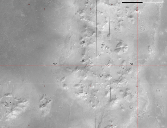
Here is a graphical index to my posts on the mid-latitude Souness GLFs. These are the objects discussed in Souness et al. 2012. They are shown in white here but not really visible at this scale. Each box is a link to my previous blog post on that zone. The various Mars Express HRSC tiles where a digital elevation model is available are outlined in black. I have used an equicylindrical coordinate system with standard parallel 40°.
The yellow crosses show the prospective landing sites for ExoMars, the thick one is the primary landing site of Oxia Planum for a 2019 landing, the two other crosses for Mawrth Vallis and Aram Dorsum which remain in contention for a delayed 2021 landing.
Hopefully the boxes are appearing in the right places.
See also a larger version (1600x800px) of this index page at my website.
Saturday, 14 November 2015
Phlegra Montes
In the final instalment of my posts giving a summary of the northern mid-latitudes of Mars, I will present the Phlegra Montes area, in the easternmost part (if you're working with -180 to 180° longitudes as I am) of the northern hemisphere.
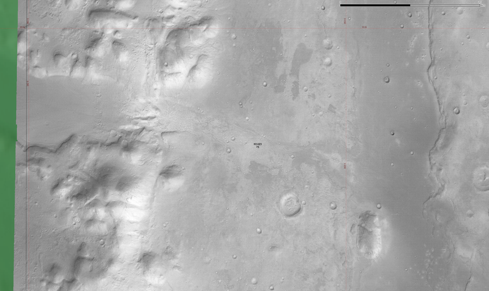
This area has some special interest taken in it lately, with a paper giving evidence for wet-based glaciation in the area written recently Eskers in a complete, wet-based glacial system in the Phlegra Montes region, Mars (Gallagher and Balme 2015). link
I use the same elevation colour ramp for HRSC tiles as in Utopia Planitia as follows:


This area has some special interest taken in it lately, with a paper giving evidence for wet-based glaciation in the area written recently Eskers in a complete, wet-based glacial system in the Phlegra Montes region, Mars (Gallagher and Balme 2015). link
 |
| The HRSC tiles h1423, h1628 and h1412 overlaid on MOC image mosaic and colourised by elevation. |
 |
| MOLA elevation alone. |
 |
| Hillshaded MOLA elevation. |
Northernmost region:

 |
| With classifier functions for 'head' and 'extent'. |
 |
| Two Souness GLFs are just missed by the HRSC coverage. |

A little further south:
 |
| Relatively few Souness GLFs are found in this area. |
 |
| In this region the GLFs are often found around relatively small isolated mesas, though many some of these do not host a catalogued GLF and look similar to the classifier. |
 |
| Close up of region around Souness 167 and 168. |
 |
| HRSC nadir image. |
 |
| With classifier function. |
Central region of Phlegra Montes:
 |
| A number of Souness GLFs are found in this area. |
 |
| With classifier function |
 |
| Zooming in a bit more |


 |
| A little to the south of the previous image |


 |
| Further to the south again |


Southern Phlegra Montes area
 |
| This covers the same region as the study areas of the Gallagher and Balme 2015 paper. They postulate wet-based glaciation in this area, arguing this was made possible by geothermal heat flux. |
 |
| Nadir images. |
 |
| With the classifier. |
 |
| The detailed study area from the paper at ~163°E, 32.5°N, with a lineated valley fill at the left and the postulated wet-based glacial forms including sinuous ridges near the centre of this image. |
 |
| HRSC nadir image |
 |
| With the classifier. |
Utopia Planitia
Most of the North of Mars is covered by a low, flat plain.
As such, there are few Souness GLFs, these being found in the walls of craters.
Here is the area of part of Utopia Planitia, north of the shield volcanoes Elysium Mons and Hecates Tholus.
I had originally titled this 'Elysium Planitia' which is in fact in another location south of the Elysium Mons massif. The URL will continue to reflect that.
Four HiRISE anaglyphs overlap or are in the vicinity of Souness GLFs:

As such, there are few Souness GLFs, these being found in the walls of craters.
Here is the area of part of Utopia Planitia, north of the shield volcanoes Elysium Mons and Hecates Tholus.
I had originally titled this 'Elysium Planitia' which is in fact in another location south of the Elysium Mons massif. The URL will continue to reflect that.
Overview
 |
| Screenshot from Google Earth showing colourised hillshaded MOLA elevation |
 |
| A small number of Souness GLFs are found inside craters in Utopia Planitia. |
 |
| Elevation colour ramp used for HRSC tiles in this area. |
 |
| Hillshaded MOLA elevation. |
 |
| MOLA elevation colour ramp. |
Four HiRISE anaglyphs overlap or are in the vicinity of Souness GLFs:
- PSP_007884_2195 (overlapping S198)
- PSP_004192_2195 (within same crater as S198)
- PSP_002214_2210 (in crater Kufra at 120°E, 40.5°N, where there are 4 Souness GLFs found.)
- PSP_002266_2190 (at 137°E, 38.5°N near S193, not covered by a HRSC DTM)
 |
| Zooming into the area covered by HRSC tiles h1526 and h2878. |

Zooming in further to several areas of interest:
 |
| Crater at 116°E, 39°N containing 3 Souness GLFs, with HiRISE anaglyph coverage of one of them. HRSC tile h1526 nadir image with the classifier results. |
 |
| 3D anaglyph PSP_007884_2195 |
 |
| A crater further north in tile h1526 at 43°N without any catalogued Souness GLFs, though there looks to be remnants of some kind of flow features. |
 |
| Classifier results show topography favoured for glaciers. |
 |
| Google Earth screenshot with HiRISE CTX imagery of crater containing Souness 193 which is not covered by any HRSC DTM tiles. The HiRISE anaglyph referenced earlier covers a portion of the eastern wall. |
 |
| Kufra Crater at 120°E, 40°N. (HRSC tile h2878 nadir image) |
 |
| Bayesian classifier results (note DTM is only at 250m resolution). |
 |
| Google Earth screenshot of HiRISE CTX imagery of Kufra crater. |
Friday, 13 November 2015
Nilosyrtis Mensae
Continuing the exploration of the northern hemisphere elevation dichotomy boundary eastward, the Nilosyrtis Mensae area is also rich in Souness glacier-like forms:
The Auqukuh Vallis system shows some striking examples of GLFs, and is highly favoured by the Bayesian classifier:
Another part of the Auqukuh Vallis system at 62°E, 32°N:
The HiRISE anaglyphs ESP_013160_2135, ESP_020597_2135 and ESP_014307_2130 are in the vicinity of, but do not overlap Souness GLFs.


 | ||
| HRSC DTMs blended with nadir image. |
 |
| This is the elevation colour ramp used for all HRSC DTMs in this region. |
 |
| MOLA elevation. |
 |
| MOLA elevation blended with hillshade. |
Auqukuh Vallis (word for 'Mars' in Quechua)
The Auqukuh Vallis system shows some striking examples of GLFs, and is highly favoured by the Bayesian classifier: |
| HRSC DTM (tile h1446 at 61°E, 31°N) blended with nadir image. Two Souness GLFs are found within this area, including HiRISE anaglyph coverage of the terminus of S312 (PSP_003482_2115). |
 |
| The nadir image alone. |
 |
| Nadir image with classifier for head (red) and extent (blue) areas overplotted. |
Another part of the Auqukuh Vallis system at 62°E, 32°N:
 |
| Five Souness GLFs are shown in this region, with HRSC DTMs of h1446 and h5173 overlaid on nadir images. |
 |
| Nadir image alone |
 |
| With classifier overplotted. |
 |
| A curious feature at 62.5°E, 32.5°N. |
Eastern Nilosyrtis
Around 68°-75°E, 28°-34°N: |
| HRSC DTM tiles (h1391, h5378, h5360, h5342, h5324, h5306) blended with nadir image. |
 |
| Nadir images only. |
 |
| Nadir images with classifier overplotted. |
Closeup of part of tile h5342:
 |
| Many Souness GLFs are to be found in this area around 73°E, 30°N. |

 |
| The classifier picks out areas of the south side of the mesa which do not have Souness GLFs catalogued. Is it possible that glaciers in south facing areas at this relatively low latitude for Souness GLFs were ablated more readily? |
Closeup of part of tile h5306 around 75°E, 30°N:
 |
| Again the 2 Souness catalogued GLFs are found on the northern side of the mesa only. |


 |
| HiRISE 3D anaglyph ESP_027823_2100 showing S204. |
Close up of h5234/h5306, showing an area further south at 28-29°N:
 |
| The southern valleys below 28°N have no Souness catalogued GLFs. The set around 74°E, 28.5°N are the southernmost Souness GLFs in the entire northern hemisphere, except S201 at 77.15°E, 27.78°N at two others in crater Lockyer at 160°E. 27.5°N. |
 |
| Nadir images only |
 |
| Nadir images with classifier. |
 |
| A closer view. The size of the alcoves suggests that the GLFs here may be the remnants of larger objects that have ablated. |


Subscribe to:
Posts (Atom)