Tuesday 30 September 2014

The lost land of Lyonesse

Here are some visualisations of Cornwall 12,000 to 5,000 years ago:

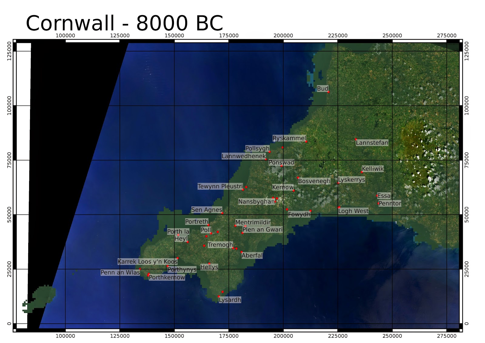
Sea level is based on Shennan and Horton 2002, with a triangular interpolation. Background is Landsat 8 from 25th July 2014. OSGB numerical coordinates.

The bathymetry is from GEBCO which has a 30 arcsecond resolution (about 600m at 50 degrees latitude). Higher resolution bathymetry is now available from the INSPIRE portal. I am planning to make some more detailed maps with this.

I've not removed man made structures including reservoirs and china clay pits. I have added a little semi-transparent dark green colour in the lower elevations to simulate dense forest in the valleys which is thought to have been the case in the Neolithic.

The Cornish name for St. Michael's Mount, is "Karrek Loos y'n Koos" - "The Grey Rock in the Wood".


Around the time period of the Younger Dryas stadial, estimated as 10,800 to 9500 BC. At the end of this stadial, the climate warmed rapidly to approximately present levels (Holocene temperature variations - Wikimedia commons).


See NOAA Paleoclimateology program for details on the 8.2ka event (6200BC), where the glacial Lake Agassiz drained in the Hudson Bay region. Legend has it that the land of Lyonesse was drowned in a single great storm.


The coastline 5000 years ago is broadly similar to today, though there are some areas such as the area near St. Michael's Mount (Karrek Loos y'n Koos) where land existed which is now submerged. In a future post I  will produce a better map from higher resolution bathymetry which is now available from the INSPIRE portal.

Dissertation done, and the likelihood of Martian glaciers in Cornwall, Wales and south-west England

So, the dissertation is done now, you can get a copy here, or a special tablet-optimised version here. The latter is using the US Supreme Court's paper size and Century Schoolbook font, as was advised to me by http://en.wikibooks.org/wiki/LaTeX/Page_Layout.

In the dissertation itself, I explain that the Martian terrain is segmented using RSGISLib and a classifier function assigned to the segments using the Souness et al. 2012 glacier-like forms as a guide.

So what if we apply it to a terrain that is not on Mars? The Shuttle Radar Topographic Mission data is available at a similar resolution to that from HRSC for Mars.

I have done the segmentation for areas of Wales, Cornwall and the southwest of England using topography only rather than integrating the red image field, since it wouldn't really be comparable with all the vegetation etc. on the Earth.

The same procedure of highlighting segments with log(K) > 12, 13, 14, 15 with a semi-transparent overlay is used. The background images are from Landsat 8 using bands 6, 5, 2 for RGB. All images from 25th July 2014.

Ordnance Survey GB numerical coordinates are used.

Not much in West Cornwall, except on the north-facing slopes west of St. Ives. There are a few more segments on the North Cornwall coast and in some areas of southeast Cornwall.
The north coast of West Penwith has a high likelihood of Martian glaciers, see also the map in the following post which shows a relatively shallow area of sea that would have been dry land in the Early Holocene, perhaps sediment deposited by the Martian glaciers at some point.

Some martian glaciers expected on the northern fringe of Dartmoor near Okehampton, but perhaps surprisingly also in south Devon.

Exmoor seems a favoured location for martian glaciers.

The Welsh valleys and the Brecon Beacons are also highlighted for a high likelihood of martian glaciers.


Since Wales generally has a higher likelihood of martian glaciers, I have used a slightly different scaling with only starting to highlight at log(K) > 13:
A close up of the Valleys and Brecon Beacons:


Mid-Wales:
North Wales:

Snowdonia:

Aberystwyth area:

The southern part of Cwm Rheidol appears particularly favoured for martian glaciers.


Thursday 18 September 2014

Cartographic decisions for dissertation

So now I've (almost) finished writing my dissertation, I'm putting in the various figures. I'm mainly using QGIS for this, most of the time the map composition feels more intuitive than ArcMap.

My previous post showed a three colour composite of showing image (or an aspect layer), elevation and slope, but I think that can be difficult to interpret, becasue a steep slope would either be blue, cyan, or magenta or white depending on what else is in the other layers.

So I'll be doing pseudocolour like this, using an image layer underlaid using transparency. I'm using meters in an Equicylindrical projection with 40 degrees latitude parallel. I think its nice to have metres as units for figures of individual objects/tiles, but maybe lat/long would work better for larger summary plots?

Elevation - overview east of Hellas

This is one of the areas I'm focusing analysis of the results for the dissertation. There are two tiles with 50m HRSC topography, and other tiles available at 75m, including the well-studied Crater Greg.

 Elevation

 Slope

I'm using a single colour ramp for slope at the moment, I think this is probably clearer than a spectral pattern.

Curvature layers

I wasn't sure which colour scheme to do this in, given they can be both positive and negative, but purple/green seems to be alright, as long as its clear which is positive.


Tuesday 2 September 2014

An overview of glaciers in the mid-latitudes of Mars

The paper by Colin Souness et al. in 2012 (link) gave an inventory of Martian "Glacier-like forms"

Here is where they are found plotted on a layerstack of Mars Express HRSC DTM tiles, where red=nadir image, green = elevation, and blue = slope, falling back to MOLA topography in areas I don't have that tile because it didn't underlay any Souness GLFs. For MOLA I use aspect as a substitute for the image layer.

The Souness GLFs are numbered, but not all are plotted because QGIS automatically avoids plotting too many labels on top of each other.

The coordinates are Mars Equicylindrical, with a standard parallell of 40 degrees.

Northern Hemisphere (25 to 65N)


Southern Hemisphere (25 to 65 S)