The conference had a number of presentations on a range of topics about the language, ranging from grammatical topics, the various manuscript sources of Cornish, to translating Cornish poetry into Italian.
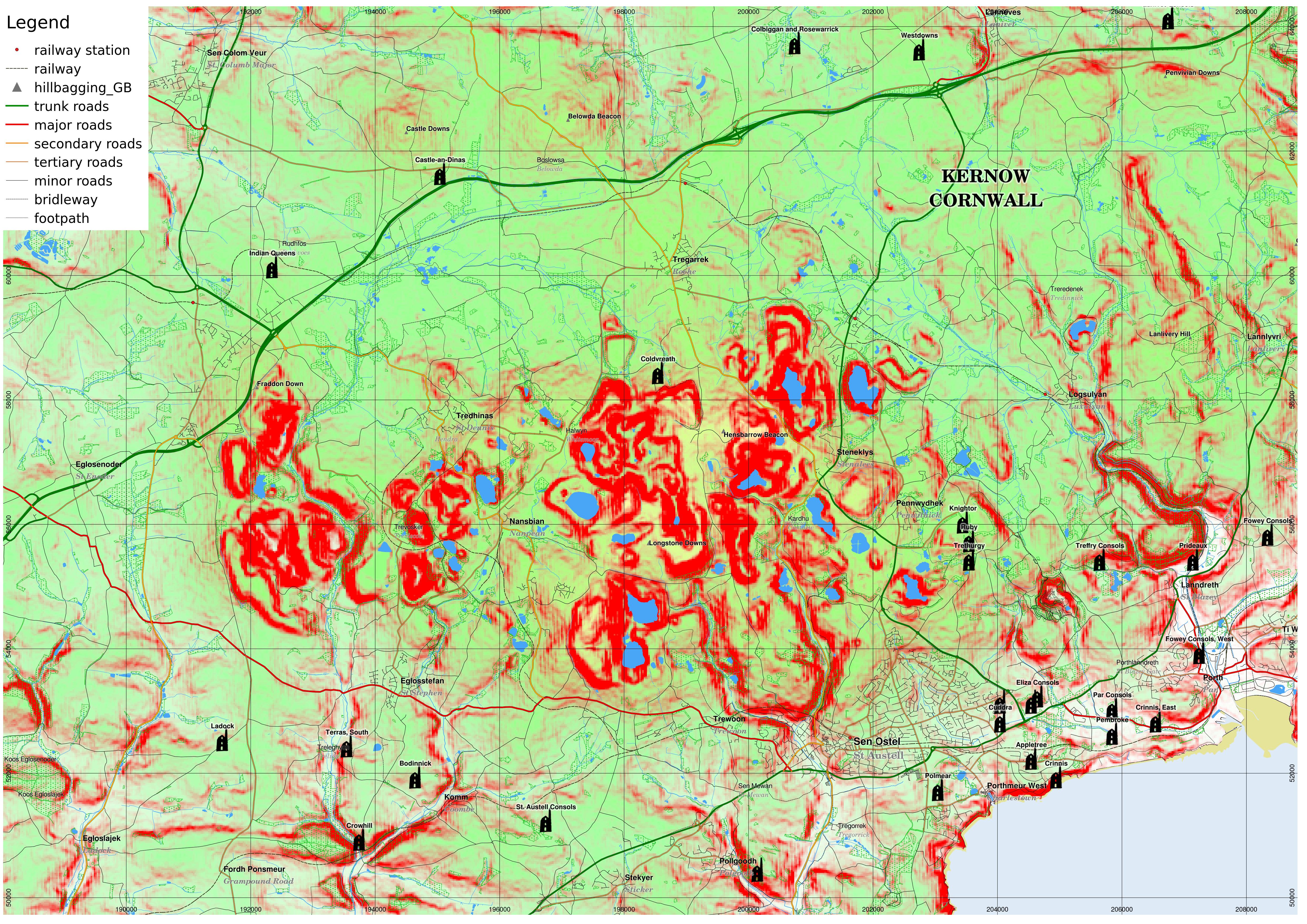
One particular topic that I thought I could shed some light on with my work on maps was Ken Mackinnon's "Henderson’s Black-more revisited: disinterring a lost landscape" which discussed the Cornish language in the china clay (kaolin) mining area of mid-Cornwall, in which the landscape itself has been altered and some of the older history obscured by the activities of the industry.
For instance, a stone called "Men Vagar" originally stood at Longstone Downs but was moved to Roche when the original site was covered by a china clay spoil heap.
Ken's presentation also said that the Cornish language had been spoken in the area until the late 17th century, which was later than I had thought.
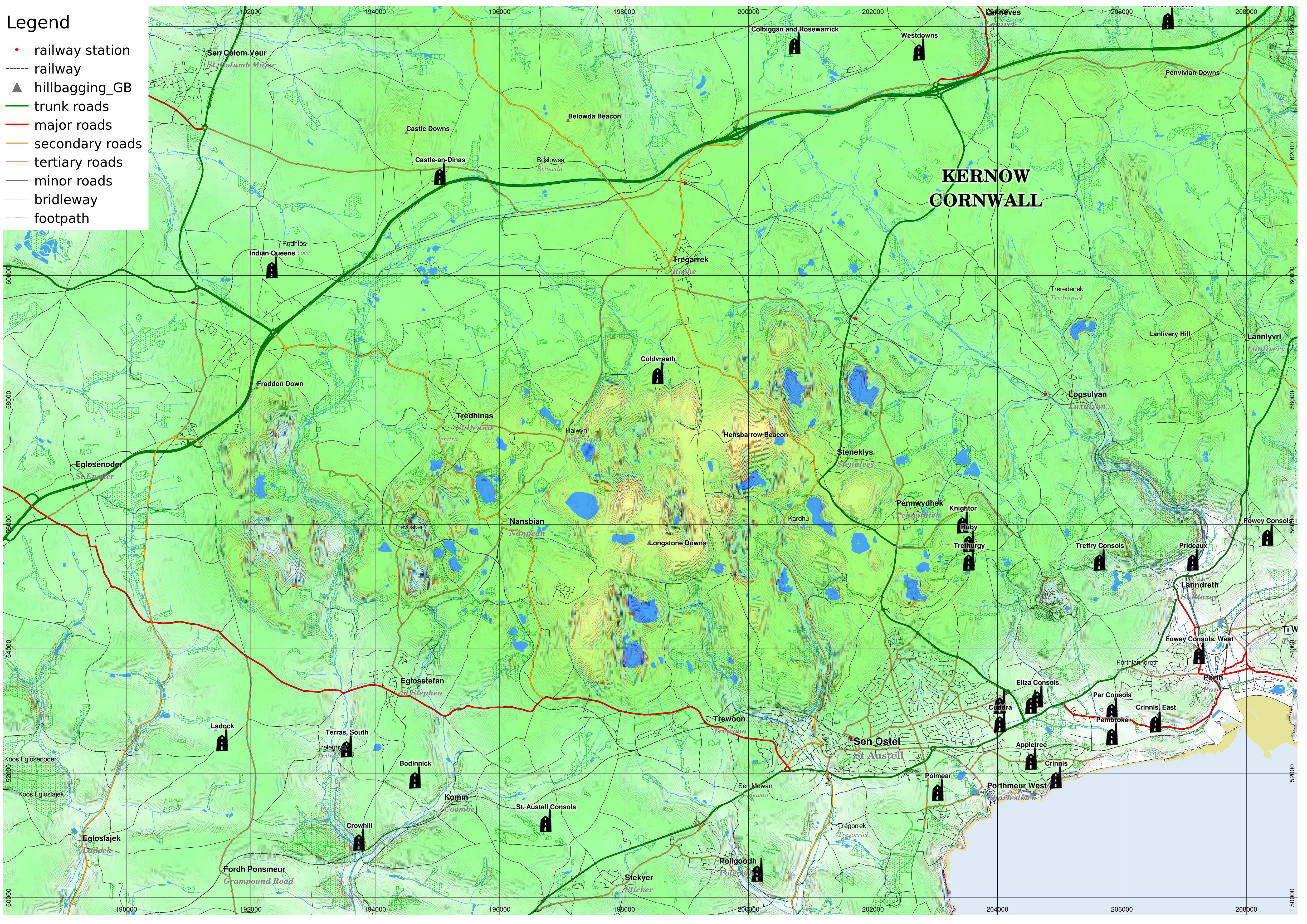
I have reproduced an extract from my own topographic maps, with names in Cornish from MAGA, and topography from the Shuttle Radar Topography Mission, and with the slope lines method that makes use of the segmentation method developed for my MSc thesis on Martian glaciology!
I also add the mines that I detailed from various sources on my website.
The elevation I show with colour shading.
Land at sea level is white, which becomes more green up to 250m. I also overlay yellow at higher elevations from 100m up to 350m.
I also have a number of hills marked from the database from www.hill-bagging.co.uk.
I overlay various vector data including roads from OpenStreetMap and foreshore, and inland water from OS Opendata layers.
 |
| In this version, I show slope with the red channel, overlaid with slopes of 15 degrees or over solid red. large version |
 |
| This version shows slope direction using the segmented digital elevation model (based on the method used in my Martian glaciology thesis). I visualise it in the way I did in some earlier blog posts, where the steeper the slope, the thicker the lines. Concave slopes are blue, convex are red, and they are black if they are planar. larger version |
 |
| Same as above, but with a different elevation colour-coding which perhaps makes it easier to see what the actual elevation is, but maybe harder to distinguish the slope lines. larger version |
Edit - OpenStreetMap landuse:'quarry'
 |
| In the landuse layer of OpenStreetMap, the 'quarry' type captures most (but not quite all) of the artificial land surfaces due to kaolin quarrying. larger version |
Excellent map (the last especially). Any ideas on programmatic ways in which one might try to use the existing (significantly man-made) topography to obtain an estimate of the topography prior to human modification ?
ReplyDelete(Could be useful for estimating required depth of excavation through man-made deposits before reaching 'natural' material. Or just for visualising, with quantifiable confidence, approximately how things looked before artificial or natural transfer of material.)
I think the easiest way is to get a map and mask any artificial land surface (i.e. spoil heap or pit) out and make that 'No Data' and then interpolate to fill the gaps based on the remaining natural land surface.
ReplyDeleteA more accurate method would be to use historical maps, and interpolate from that. Interpolation exists as a QGIS plugin.
There is actually under 'landuse' on OpenStreetMap, a type 'quarry' which covers most of the china clay pits. See www.openstreetmap.org/#map=12/50.3999/-4.8791. It doesn't necessarily cover all artificial surfaces, I notices a few of the spoil heaps fell outside of it.
ReplyDelete