Showing posts with label bathymetry. Show all posts

Tuesday, 13 October 2015

The Lost land of Lyonesse revisited

In a previous post, I mentioned the work of Shennan and Horton (2002) about sea level change around Britain through the Holocene.

I showed a visualisation of the West Cornwall coastline as it may have been around 12,000 years before present.

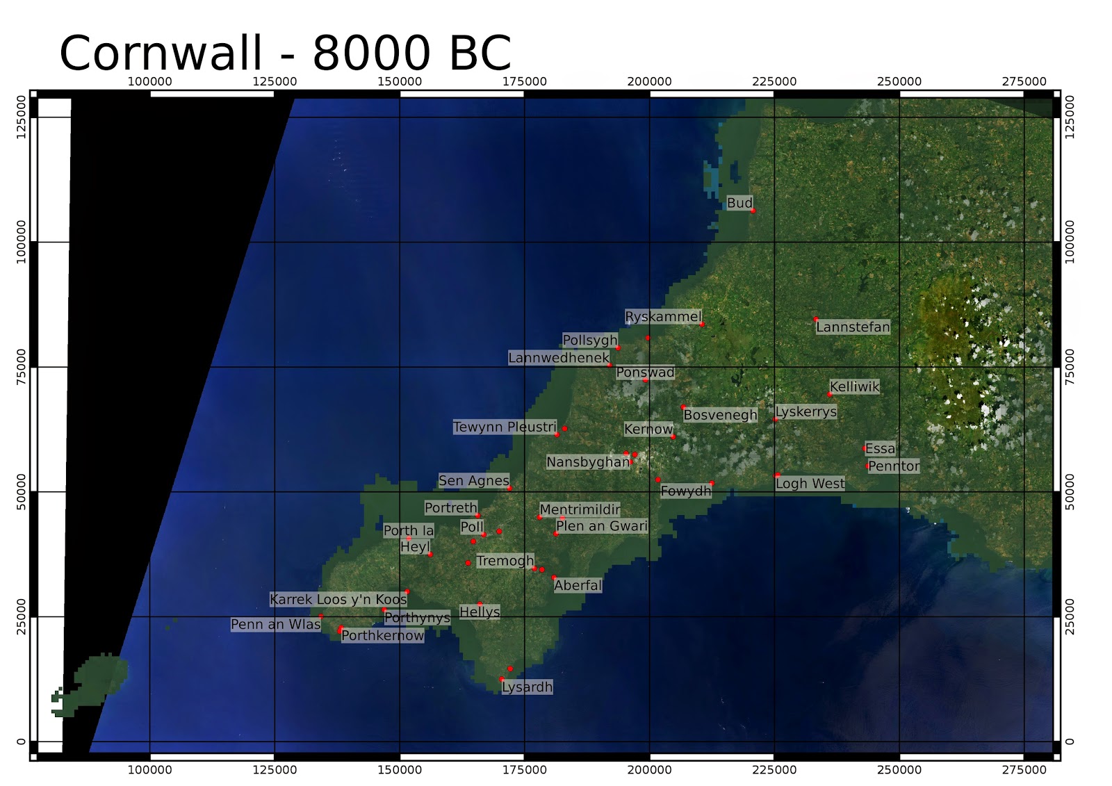
After downloading further bathymetry via the UKHO INSPIRE portal, I present an updated version covering the whole area around Cornwall.

Much of this came as .csv point data, which I had to grid, and use the QGIS Concave Hull plugin from the Processing toolbox to restrict the interpolated grid to where there was data.

In some areas, there are gaps in what is currently available at high resolution so it falls back to low-resolution data.

Based on my reading off the graphs in Shennan and Horton, the sea level rise at this time should be similar across the area covered here:
 
Site Number Site Name Lat Long RSL 1kyr RSL 2kyr RSL 3kyr RSL 4kyr RSL 5kyr RSL 6kyr RSL 7kyr RSL 8kyr RSL 9kyr RSL 10kyr RSL 11 kyr RSL 12 kyr

42 Pembroke 51.8 -5.1 -0.8 -1.6 -2.4 -3.2 -4 -9.2 -14.4 -19.6 -24.8 -30 -35.2 -40.4
43 Glamorgan 51.5 -3.7 -2 -4 -6 -8 -10 -13.6 -17.2 -20.8 -24.4 -28 -31.6 -35.2
51 Devon 50.4 -3.5 -1 -2 -3 -4 -5 -10 -15 -20 -25 -30 -35 -40
52 Cornwall 50.2 -5.5 -1.4 -2.8 -4.2 -5.6 -7 -11.6 -16.2 -20.8 -25.4 -30 -34.6 -39.2


It is clear there were substantial areas of land that were disappearing in the millenia after the reoccupation of Britain after the last glacial maximum (with this map corresponding to the cold spell of the Younger Dryas).
In the period of time, between 12kyr BP and 8kyr BP sea level rose by 20m, which corresponds to half a metre every century.
Especially in the large expanses of gently sloping terrain off the north coast, it would be likely that coastal retreat would have been noticeable by people within a single lifetime.

A version speculating about woodland colonising the lowlands:

Monday, 27 July 2015

The Lost Land of Lyonesse - update with high resolution bathymetry

I found high resolution bathymetric data available via the INSPIRE portal from UK Hydrographic Office.

So I thought it time to update my previous post on the lost land of Lyonesse, off the coast of Cornwall.

I was interested to find out what sea level the first people to inhabit Britain in a post-glacial climate around the Younger Dryas stadial (12 kyr BP) may have encountered.

The bathymetry from the above link comes in small sections and not all areas have ready gridded data so there is a background from the General Bathymetric Chart of the Oceans which has a resolution of 30 arcseconds (about 600m here) but resampled to 48m/pixel for a less pixellated look.

For this reason, and also to not worry about differential post-glacial rebound across the area, I have concentrated on West Cornwall. I have used the same assumptions of it as my previous post on the subject, that is the Shennan + Horton 2002 paper primarily also referring to the work of Kurt Lambeck.
I have assumed that sea level was 40m lower 12kyr BP,  30m lower 10kyr BP, 2m lower 8kyr BP, 16m lower 7kyr ago, 12m lower 6kyr ago, and 7m lower 5kyr ago.

I have taken no account of sediment deposition/erosion after marine transgression.

I have accidentally labelled Universal Transverse Mercator zone 30N coordinates rather than Ordnance survey grid coordinates,the units are however still in metres.

The elevation shading restarts from zero for the land, but incrementing in 20m steps rather than 2m. The first shaded colour on land is light green at 40-60m (12kyr ago).

Let me know what you think in the comments.

In legend Lyonesse is supposed to have connected Cornwall to Scilly. We see above that this is not likely to have been the case in a post-glacial climate since there is deep water of > 70m below present sea level between Land's End and Scilly. However substantial areas in Mount's Bay and north of St. Ives would have been dry land, up to about 8 kyr ago (sea level assumed to be 20m below present).
Unfortunately I don't currently have wide area gridded high-resolution bathymetry around Scilly. The inundation of the area between the currently inhabited islands occurred rather later than would be indicated by the labelling of this map, since this is known to have been dry land in historical times.


Close-up of area north of St. Ives and Hayle. A relatively large area of land would be been likely to have been submerged between about 9kyr and 7kyr ago.


The Cornish name for St. Michael's Mount, Karrek loos y'n koosmeans 'the grey rock in the woods'. At 5kyr ago, sea level is assumed to be 7m below present (i.e the pink land).


A bit of artistic licence, imagining vegetation colonising the lowlands, with the uplands still sparse at this stage (shortly after Younger Dryas 12-11yr ago)

Thursday, 15 January 2015

The Doggerland Reclaimation Project

As an entry to John Michael Greer's Great Squirrel Case Challenge (the name based on a proposal by high-school debaters in Seattle to generate the USA's electricity by vast numbers of squirrels turning wheels), here is my proposal for the world's most absurd energy solution:

The Doggerland Reclaimation project would use a series of dikes to allow the drainage of part of the North Sea using power generated by offshore wind farms along a dike from Aberdeen, Scotland to Bergen, Norway.

A second dike from Dover to Calais would allow water in to generate hydroelectric power. This would also carry a new motorway link to complement the Channel Tunnel and be linked to a new container port to replace Rotterdam and Hamburg.

The lowered sea would make the shallower southern part of the North Sea dry land which would be planted with fast-growing conifers for wood-chip biofuel power plants.

Wednesday, 1 October 2014

The disappearence of Cantre'r Gwaelod

Again based on Shennan & Horton 2002:


Now just a little bit beyond the present coastline in certain places, such as near Borth where the preserved forest can be seen when the sea strips back the sand (often low tides after storms are a good time to see it).

Tuesday, 30 September 2014

The lost land of Lyonesse

Here are some visualisations of Cornwall 12,000 to 5,000 years ago:

Sea level is based on Shennan and Horton 2002, with a triangular interpolation. Background is Landsat 8 from 25th July 2014. OSGB numerical coordinates.

The bathymetry is from GEBCO which has a 30 arcsecond resolution (about 600m at 50 degrees latitude). Higher resolution bathymetry is now available from the INSPIRE portal. I am planning to make some more detailed maps with this.

I've not removed man made structures including reservoirs and china clay pits. I have added a little semi-transparent dark green colour in the lower elevations to simulate dense forest in the valleys which is thought to have been the case in the Neolithic.

The Cornish name for St. Michael's Mount, is "Karrek Loos y'n Koos" - "The Grey Rock in the Wood".


Around the time period of the Younger Dryas stadial, estimated as 10,800 to 9500 BC. At the end of this stadial, the climate warmed rapidly to approximately present levels (Holocene temperature variations - Wikimedia commons).


See NOAA Paleoclimateology program for details on the 8.2ka event (6200BC), where the glacial Lake Agassiz drained in the Hudson Bay region. Legend has it that the land of Lyonesse was drowned in a single great storm.


The coastline 5000 years ago is broadly similar to today, though there are some areas such as the area near St. Michael's Mount (Karrek Loos y'n Koos) where land existed which is now submerged. In a future post I  will produce a better map from higher resolution bathymetry which is now available from the INSPIRE portal.