Showing posts with label maps in cornish. Show all posts

Thursday, 8 October 2015

A greyscale version of my maps in Cornish

I have made a greyscale version of the maps in Cornish I have been working on.

Here is an extract from the Truro area:

Cornish placenames from MAGA Placename and Signage Panel and the book by Craig Weatherhill. Some names of geographic features are my own translations of English names. Any errors are my own responsibility. large version


Adding arrows to indicate the (downward) slope direction using the segmentation method described in earlier posts. large version
Keeping the map greyscale but showing longitudinal curvature of the slope with convex slopes in red and concave in blue. large version
Penzance. Unfortunately using the arrows tends to make QGIS run very slowly and crash for larger maps. larger version

Sunday, 31 May 2015

Some more work in progress re: Cornish GIS maps

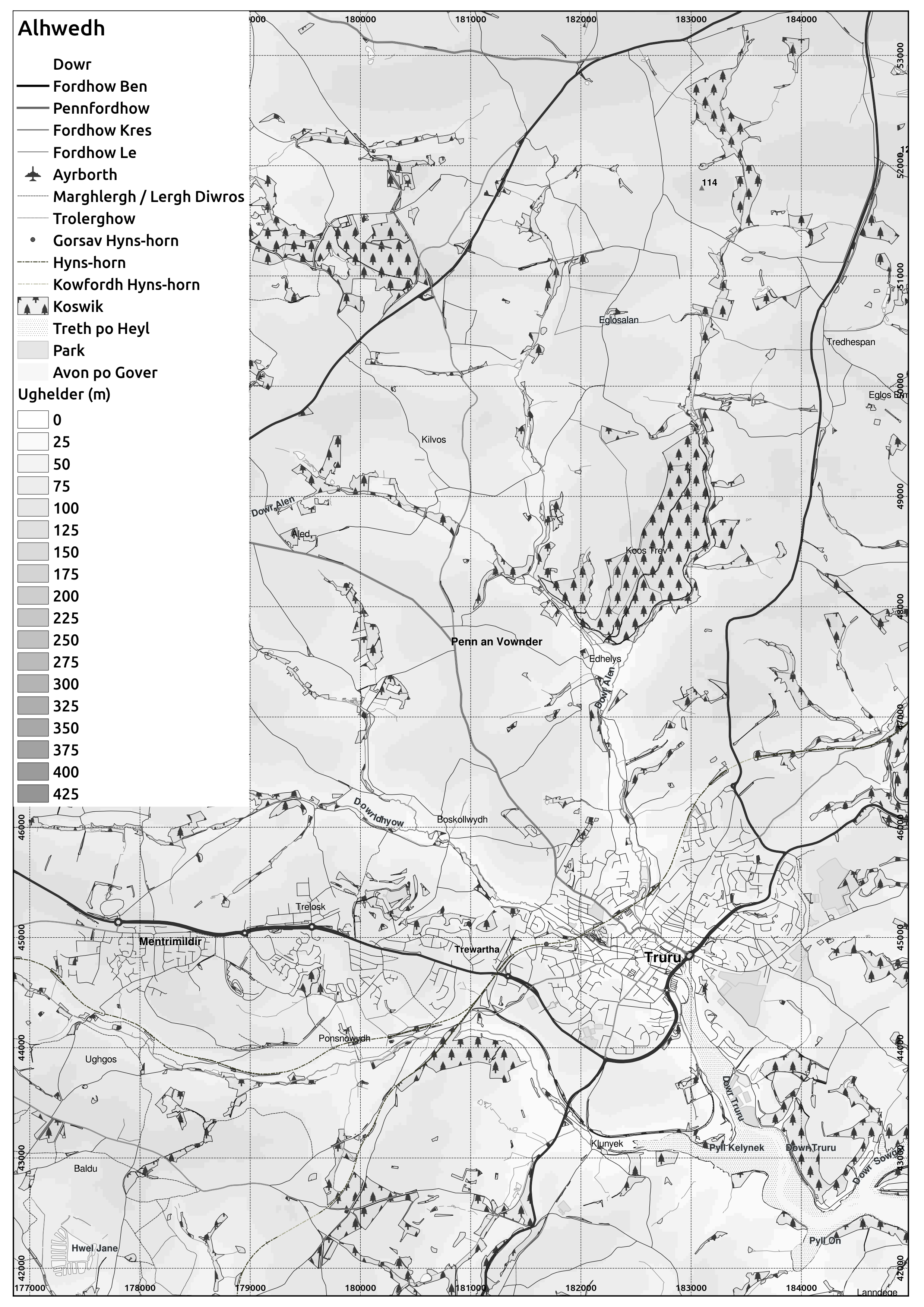
Here is a little more about my work in progress in generating maps of Cornwall in QGIS.

I have downloaded various Ordnance Survey VectorMap data, along with some layers which come from OpenStreetMap. The OS VectorMap has layers including woodland, tidal water, surface water polygons (e.g. lakes and reservoirs), foreshore and surface water lines (rivers etc.) and others.

These is more comprehensive than OpenStreetMap, however the OpenStreetMap vector layers come with names associated with them in the attribute table in some cases. Certain of the OS VectorMap layer objects will exist in the VectorMap 'Named Places' shapefile, but as points rather than as names in the attribute tables of the polygons themselves.

In the map below I have used the woodland polygons from the OS VectorMap and the ones from OpenStreetMap, but only the OpenStreetMap ones are labelled, since only they have names in the table.

I have also generated contours based on the Shuttle Radar Topography Mission, 1 arcsecond data, which is now freely available for most of the world. It is also possible to use OS Terrain50 contours, which generally appear smoother than these ones, however given these are released in individual squares, I found myself having so many vector layers in the rendering that QGIS crashed.

The Falmouth area, using contours from SRTM 1 arcsec
There is a fairly large amount of data entry to be done to put the names in Cornish, and beyond the list that has already been published by MAGA I would expect it to be slower work.

The OS VectorMap Named Places shapefile for the SW grid square has 2759 entries, of which 679 are various geographic features and the remainder are populated places.

The OpenStreetMap files have approximately 122 named woodlands in Cornwall (of 810 polygons, of over 9000 in the SW grid square alone for OS VectorMap), 56 named water polygons (of 327), 21 parks (of 45), 242 named waterways (of 2923) as lines (some duplicate names for different parts of a feature), and 1337 named places (of which I have already entered 421 in Cornish based on the MAGA Kernow list). There are 10342 named roads in Cornwall from the Open Street Map data.

Monday, 13 April 2015

Website on Neocities - Taklow Kernewek

I've been developing a website on Neocities, which includes a version of the map of Yeth an Werin meetings for people to speak in Cornish, a set of maps of mines of Cornwall and a little about language tools in Python.

As its mainly going to be focused on Cornish, I've called it Taklow Kernewek, or "Cornish Things".

I will add a bit more of the language stuff as time goes on, and eventually some of the geographical stuff I've done in QGIS including the map of Cornwall in Cornish.

Friday, 2 January 2015

Cornwall, rotated by 50 degrees

Having had Graham Robb's "The Ancient Paths" for Christmas, I note that the author noted the importance of the bearing of the rising Sun on the summer solstice to the ancient Celts of Gaul.

So here are a few maps of Cornwall which have been rotated such that 50 degrees east of North is up:

I've also altered the elevation pallete to make fuller use of it compared to my previous maps.


Thursday, 4 December 2014

Improved version of Cornwall maps in Cornish

As I said in my previous post, there were some areas such as river estuaries showing land where which is actually water. 

Using layers from www.mapcruzin.com (ultimately from OpenStreetMap) I add inland water, rivers, woodland and parks (semitransparent overplot). 

Using data dependent properties in QGIS, vary plotting of label text dependent on type (e.g. town, village) as specific in the placename layer.

edit: The Cornish placenames themselves are the list in the Standard Written Form produced by the MAGA Signage Panel.

Scale of 1:200000 for the below pages printed at A4.


Some manual editing was necessary to ensure the Cornwall/Devon border conforms to the treaty of 936 between kings Athelstan and Huwel.


 Maps for A3 paper


Tuesday, 28 October 2014

A map of Cornwall in Cornish

The Cornish Language Partnership has a list of placenames in Cornwall in the Cornish language.

I have downloaded a shapefile with locations of places from www.mapcruzin.com which ultimately derives from OpenStreetMap. To this I have added the Cornish placenames, and plotted on a map in QGIS.

I still need to add in other features like rivers etc., and find something to make sure that estuaries like the Fal are shown as water rather than appearing to be dry land.

The colour scheme might look familiar if you remember the old Bartholomews 1:100k maps.